

Baie de Cook (Paopao)
VerifiedSociety Islands, Moorea, Paopao
- Cook's Bay Moorea
- Paopao viewpoint
- Cook's Bay panorama
About
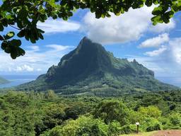
Cook’s Bay, also called Paopao Bay after the village at its far end, cuts deeply into Moorea’s north coast. It is one of the island’s most photographed landscapes: calm, dark water framed by vertical ridges, with Mount Rotui on one side and the island’s inland peaks on the other.
The coastal road follows the eastern shore of the bay. A viewpoint known as Panorama de Pao Pao is beside the road, shortly before reaching the head of the bay. From here, you can see the entire body of water, sailboats at anchor and, on some days, a cruise ship anchored in the middle of the bay.
Despite its name, this is not where James Cook anchored during his visit to Moorea in 1777: he anchored in neighboring Opunohu Bay, on the other side of Mount Rotui. The two bays work well together in the same day, and the Opunohu lookout, higher up the valley, offers a view of both at once.
The stop is free and open to all. Park only on clear shoulders and take care: the coastal road is narrow and busy here. The light is softest in the early morning and late afternoon.
The village of Paopao, at the head of the bay, has a municipal market and a few shops for a break. Photos: Alain.martre, CC BY-SA 4.0; Daniel Julie, CC BY 2.0; gérard, CC BY-SA 2.0; Matthew Dillon, CC BY 2.0; Jp2207, CC0 (via Wikimedia Commons); Google Maps.
Other spots on Moorea


Discover Opunohu Bay in Moorea, its lagoon viewpoint and Ta’ahiamanu Beach, then head to the marae and the Opunohu lookout.
Discover Belvédère d’Opunohu in Moorea, with views over the bays, hiking trails and restored Polynesian ceremonial sites in the valley.

Discover the panorama from To’atea Lookout in Moorea, with views of Temae Lagoon, the white-sand beach and the island of Tahiti.

Diving the Opunohu Canyons off northern Moorea: ledges, overhangs, caves, blacktip and lemon sharks, suitable for all diving levels.