
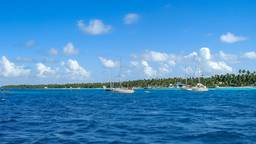
Village de Garumaoa et lagon de Raroia
VerifiedTuamotu, Raroia, Garumaoa
- Garumaoa village
- what to see in Raroia
- Kon-Tiki atoll
About
Raroia, formerly Raro-nuku, is a large oval atoll in the east-central Tuamotus, about 740 km east of Tahiti. Measuring 43 km long and 14 km wide, its ring of around a hundred motu surrounds a lagoon of more than 350 km², dotted with coral pinnacles: Tahiti Heritage describes it as the atoll in Polynesia richest in these “heads” that reach the surface. Its roughly 250 to 300 inhabitants live almost entirely in Garumaoa (sometimes written Ngarumaoa), the only village, set on the west coast, on the lagoon side, a few kilometres from Garue Pass (or Ngarue), the lagoon’s only entrance.
Garumaoa can be explored on foot in an hour: a white coral road lined with coconut palms, flower-filled houses and faré, Saint-Michel Church and its presbytery, the nearby Grotto of the Virgin, the town hall, a public building with arcades marked “Raronuku,” the atoll’s old name, and the small wharf where the village boats dock. On the lagoon side, a narrow beach of sand and coral looks out over deep blue water: fishing and pearl-farming boats can be seen passing, along with a few visiting sailboats at anchor during the season. At the end of the day, the lagoon shore is the best place to watch the sun set behind the coconut palms.
Raroia’s history is remarkable. According to tradition, the island was settled by Polynesians from the Marquesas; Quirós is said to have sighted it in 1606, and Bellingshausen named it Barclay de Tolly in 1820. Around 1875, the atoll had about a thousand inhabitants, divided between Garumaoa and Tetou, on the windward coast, a village destroyed by a cyclone in 1878. Saint-Michel parish was founded around 1850 and the church was built in 1877. On August 7, 1947, Thor Heyerdahl’s Kon-Tiki raft ran aground on Raroia’s reef, on Tahunamaru motu, after 101 days adrift from Peru. One of its crew members, the Swede Bengt Danielsson, returned to live there and wrote a book that became a classic, L’île du Kon-Tiki. Kon-Tiki motu lies on the other side of the lagoon and can only be reached by boat.
The airstrip, south of the village, receives about one flight a week from Tahiti, and a supply ship calls twice a month. There is no bank or car rental: bring cash, water and sun protection. Stay on the road and in public areas: coconut groves, pearl farms and house yards are private; ask before entering. The wharf is a place of work: leave room for the boats. Garue Pass is rough in strong winds and its currents are dangerous: do not swim there without a local guide. Do not touch the coral, and take your rubbish with you.
Photos: Google Maps contributors (“Raroia” and “Ile Raroia” listings); Tahiti Heritage and Grovenstein / Wikimedia Commons (CC BY-SA 3.0).